

In geotechnical engineering, making informed decisions requires a deep understanding of how soils and structures interact under various conditions. Traditional methods, while reliable, can be limited in predicting complex behaviors or rare scenarios. By combining real-world data with advanced simulation techniques, engineers can gain a more comprehensive view of potential challenges and outcomes. This approach enables more accurate risk assessments and informed planning, ultimately enhancing project safety and efficiency.
Numerical modelling plays a crucial role in this process, translating collected data into predictive simulations that reveal insights not easily captured through observation alone. Integrating these models with field measurements enables engineers to anticipate issues, optimize designs, and make informed decisions, ensuring that geotechnical projects are both resilient and cost-effective throughout their planning, execution, and implementation.
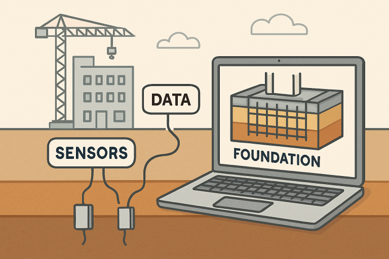
The Role of Data in Geotechnical Engineering
Data is at the heart of modern geotechnical engineering strategies. Through advanced field investigations, professionals gather vital information about soil composition, density, moisture, strength, and other properties. Beyond these fundamentals, sensors and automated monitoring networks now provide near-instantaneous updates on site conditions, supporting real-time adjustments during earthworks and construction activities. Data-driven practices have significantly improved the ability to forecast settlement, assess slope stability, and design deep foundations.

Advancements in Simulation Techniques
Geotechnical engineering has witnessed a significant transformation thanks to advancements in simulation techniques. Modern simulations enable engineers to model complex soil-structure interactions with unprecedented accuracy, allowing for more reliable predictions of performance under varying loads and environmental conditions. These tools reduce reliance on traditional trial-and-error approaches, saving time, resources, and minimizing risks associated with unexpected ground behavior during construction.
One key development is the integration of numerical modeling with high-resolution data, which enables more realistic and dynamic simulations. When combined with thorough site characterization, including soil sampling, in-situ testing, and geophysical surveys, engineers gain a comprehensive understanding of the subsurface conditions. This combination of simulation and detailed site data boosts decision-making, increases design reliability, and results in safer, more affordable geotechnical solutions across various projects.
The quick brown fox jumps over the lazy dog. The heart has its reasons which reason knows not. I took a deep breath and listened to the old brag of my heart.
Integrating Data and Simulation: A Case Study
Real-world integration is already reshaping the industry. For example, the partnership between Fugro and Autodesk resulted in the development of the GeoDin Ground plugin for Autodesk Civil 3D, a groundbreaking digital solution. By centralizing diverse geotechnical data—such as boreholes, laboratory results, and geophysical surveys—into a single digital environment, the tool streamlines project workflows. Engineers now have a comprehensive, current view of site conditions, supporting decisions that reduce cost overruns and better comply with regulatory standards. This approach echoes a broader trend toward “single sources of truth” in engineering data, promoting clarity and cooperation across multidisciplinary teams.
Benefits of Data-Simulation Integration
- Enhanced Accuracy: Continuous data input allows models to adapt and refine predictions, resulting in more fault-tolerant designs for foundations and retaining structures.
- Risk Mitigation: Early detection of ground movement or anomalous conditions enables teams to implement preventive solutions before critical issues arise, thereby reducing both project risk and remediation costs.
- Resource Optimization: A deeper understanding of subsurface realities enables teams to select the most suitable construction techniques and materials, reducing waste and enhancing sustainability efforts.
- Safety Improvements: With greater model reliability, safety protocol design benefits from a realistic understanding of ground behavior in both ordinary and extreme conditions. Real-time monitoring feeds further enhance construction safety.
Challenges and Considerations
Despite advancements, the integration of geotechnical digital systems presents key challenges. Investing in software, sensors, and data management infrastructure can be substantial, and smaller organizations may struggle to adopt it. Data reliability is another concern; incomplete or low-quality information can compromise model accuracy, resulting in costly errors. Organizations must prioritize proper data management and security practices to protect sensitive project information and ensure that they achieve insightful, actionable results.
Future Directions
Ongoing technological progress points toward an even closer bond between data and simulation. The emergence of digital twins—sophisticated digital representations of sites that continuously evolve using live data—heralds a future where prediction and adaptation occur in real time. Digital twins have already found application in critical sectors, such as carbon capture and storage, and their growing use promises to further elevate risk management and operational efficiency in geotechnical undertakings.
Conclusion
The convergence of data and simulation sets a new standard for the geotechnical industry. As design and construction challenges become increasingly complex, engineers who utilize these digital tools are well-positioned to deliver safer, more resilient, and cost-effective projects. Investing in advanced data collection, simulation, and collaborative platforms is crucial for organizations aiming to remain competitive and innovative in an evolving field.


